 |
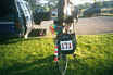
Early Sunday morning. I was rider number 171. Having something
distinctive on your bike like the pinwheel is a great way to get
people to remember you. "You know, I'm the guy with that stupid
pinwheel." "Oh, yeah..."
|
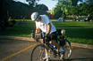 |
Trying to get in the toe clips and set off for Medina.
|
 |
Riding along the streets of Buffalo to get to the canal
and the trail.
|
 |
The first view of the canal. This is in Tonawanda and the
view is roughly to the east.
|
 |
Erie Canal looking east. About 8 miles west of Lockport.
|
 |
The lunch stop at Lockport. The canal is in the background and
the view is to the east.
|
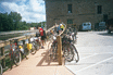 |
Bikes parked at the Lockport lunch stop.
|
 |
Here's a boat that takes people for a ride through the locks at
Lockport. One of the snafus of the tour was that there weren't
nearly enough spaces on the boat for all the riders that wanted
to go on the boat and had been told that they could go. You'll
notice that I'm taking a picture of the boat from the dock, not
the dock from the boat, so you can tell which group I'm in.
|
 |
Once I regained my temper, I discovered that the locks were less
than a mile away. Ann, Stan and I rode to the locks. Here's a
view to the east showing the lower of the double locks at
Lockport.The level in the lock is the same as that in the canal.
The downstream bridge you see is called the upside down bridge
because the truss work is under the bridge (hard to see in the
picture). I don't have a clue what the engineering reason for
doing this might be.
|
 |
The gate on the upstream side of the lower lock. I estimated that
the spacing between the horizontal ribs in the gate is about 4
feet.
|
 |
Here I am on the bridge over the locks with the upper lock and
Lockport in the background. Picture by Ann.
|
 |
Four boats are in the upper lock. The boat that we didn't get on
is the rear one on the left.
|
 |
The other side of the gates separating the upper and lower locks.
This is from a foot bridge across the locks. The previous picture
of the gates was from the auto and pedestrian bridge you can see
at the top of the picture.
|
 |
Water runs out of the upper lock into the lower lock. The boats
have lines looped around vertical lines attached to the sides of
the lock. This keeps them anchored while the water level changes.
The woman on the right front boat pushes on the wall with a pole
to keep her boat from scraping and possibly getting hung up on
the wall. (Nobody else seemed to worry about this.)
|
 |
The gates start to open.
|
 |
The tour boat with cyclists and others moves from the upper to
the lower locks.
|
 |
Now the four boats are in the lower lock, the gates are closed
and they're waiting for the water level to lower to the
downstream canal level.
|
 |
On the side of the double locks are the remains of the five
original locks that raised and lowered boats the same height. The
original towpath runs along the left side of the canal. This is
one of the areas where the barge canal, the widened canal, and
Clinton's Ditch follow the same route.
|
 |
The tour boat leaves the lower locks. As it turns out, it was
probably better to see the locks the way we did than to ride the
tour boat. For one thing you only had to see them once!
|
 |
Ann and Stan ride along the towpath east of Lockport. They are
headed to Medina (pronounced meh di' neh - long i in the middle).
|
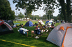 |
Tent city at Medina. The volunteers made us a tasty dinner in the school
cafeteria. We also had breakfast there the next morning. That's
Warren and Pam relaxing next to their tandem.
|
|
|